1865 Map of Middle Tennessee
These maps are the 5 sheets of the 1865 Army Corps of Engineers map that the National Archives calls Record Group 77 (Records of the Office of the Chief of Engineers), Civil Works Map File, File Unit T, Map Number 84 ½ - 1.
The original map, in 5 sheets, is at the National Archives 2 facility in College Park, MD. The map covers much of middle Tennessee, except for the southern tier of counties. It covers from the Tennessee River in the west to Cookeville in the east, showing towns, roads, railroads, landmarks and landowners. Details are better the farther north and west you go on the map.
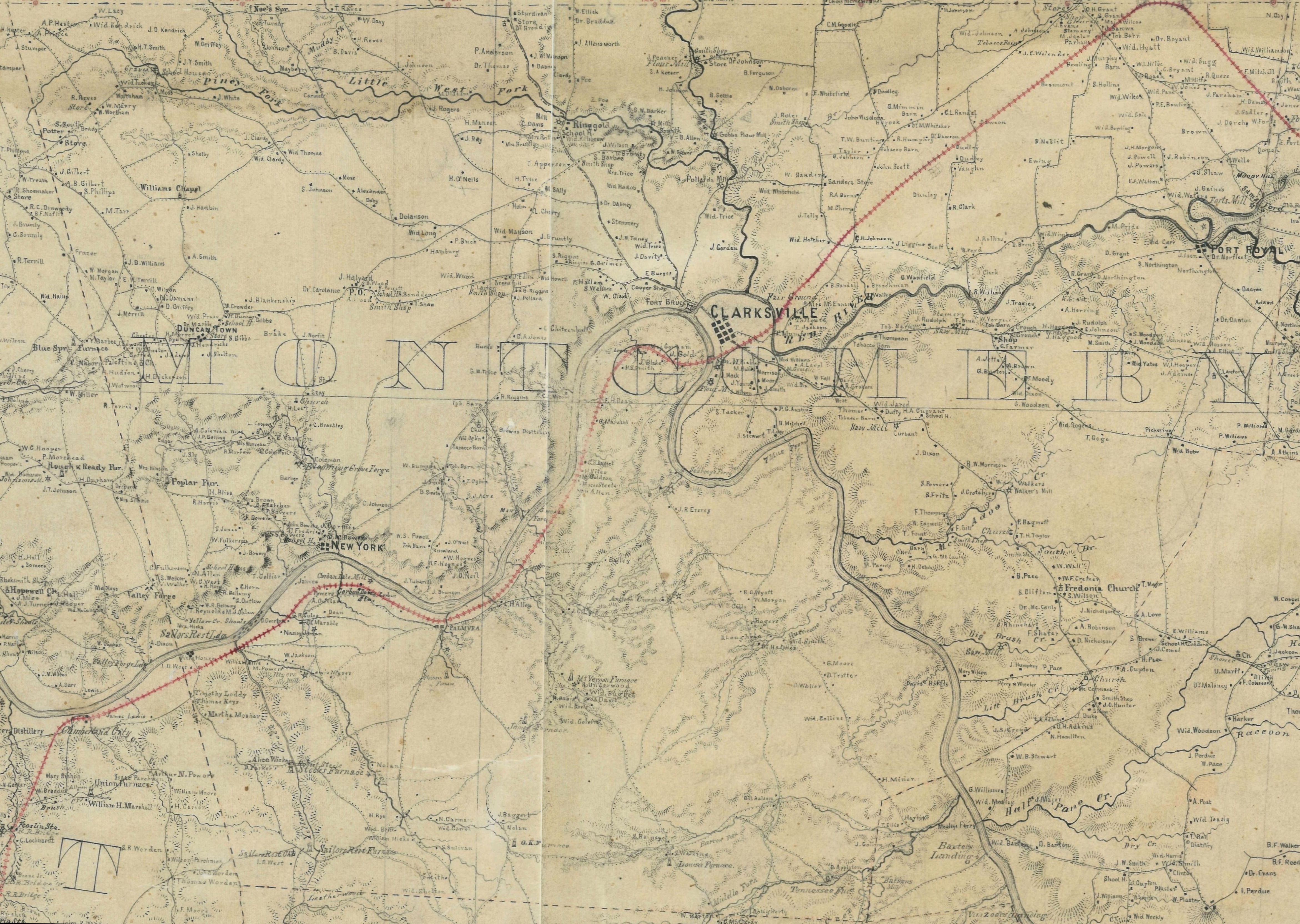
Sheet #1 (file below - color, hi-res acquired 2010 from NARA): bounded on the west by the Tennessee River, north by the Kentucky line, south almost to Linden, east almost to Clarksville (incl. Ringgold) and including Centerville. Includes the legend for the entire map.
Sheet #2 (file below - color, hi-res acquired 2010 from NARA): bounded on the west by Clarksville (Ringgold)/Charlotte/Centerville, north by the Kentucky line, south to Columbia, east to Cottontown/Smyrna. Includes Nashville.
Sheet #3 (black/white, lower-res from the Tennessee Virtual Archive website): bounded on the west by Gallatin & Murfreesboro, north by the Kentucky line, south to Fosterville & Beech Grove, east to McMinnville, Rock Island and Sparta. Includes Hartsville, Lebanon, Lafayette, Gainesboro, Livingston, Carthage.
https://teva.contentdm.oclc.org/digital/collection/p15138coll23/id/10336/rec/125
Sheet #4 (black/white, lower-res from the Tennessee Virtual Archive website): bounded on the west by the Tennessee River, north by Linden, south to 35 degrees north latitude, east to just south of Columbia. Includes Perryville, Savannah. This sheet has the least amount completed.
https://teva.contentdm.oclc.org/digital/collection/p15138coll23/id/10337/rec/125
Sheet #5 (black/white, lower-res from the Tennessee Virtual Archive website): bounded on the west by Lewisburg, north to Bell Buckle, south to 35 degrees north latitude, east to Beersheba Springs. Includes Wartrace, Shelbyville, Fayetteville, Winchester.
https://teva.contentdm.oclc.org/digital/collection/p15138coll23/id/10338/rec/125
Sheets 1-5 in composite (lower-res from the Tennessee Virtual Archive website)
https://teva.contentdm.oclc.org/digital/collection/p15138coll23/id/10339/rec/125
Shared by Jim Long, Clarksville, TN
[email protected]
These maps are the 5 sheets of the 1865 Army Corps of Engineers map that the National Archives calls Record Group 77 (Records of the Office of the Chief of Engineers), Civil Works Map File, File Unit T, Map Number 84 ½ - 1.
The original map, in 5 sheets, is at the National Archives 2 facility in College Park, MD. The map covers much of middle Tennessee, except for the southern tier of counties. It covers from the Tennessee River in the west to Cookeville in the east, showing towns, roads, railroads, landmarks and landowners. Details are better the farther north and west you go on the map.
Sheet #1 (file below - color, hi-res acquired 2010 from NARA): bounded on the west by the Tennessee River, north by the Kentucky line, south almost to Linden, east almost to Clarksville (incl. Ringgold) and including Centerville. Includes the legend for the entire map.
Sheet #2 (file below - color, hi-res acquired 2010 from NARA): bounded on the west by Clarksville (Ringgold)/Charlotte/Centerville, north by the Kentucky line, south to Columbia, east to Cottontown/Smyrna. Includes Nashville.
Sheet #3 (black/white, lower-res from the Tennessee Virtual Archive website): bounded on the west by Gallatin & Murfreesboro, north by the Kentucky line, south to Fosterville & Beech Grove, east to McMinnville, Rock Island and Sparta. Includes Hartsville, Lebanon, Lafayette, Gainesboro, Livingston, Carthage.
https://teva.contentdm.oclc.org/digital/collection/p15138coll23/id/10336/rec/125
Sheet #4 (black/white, lower-res from the Tennessee Virtual Archive website): bounded on the west by the Tennessee River, north by Linden, south to 35 degrees north latitude, east to just south of Columbia. Includes Perryville, Savannah. This sheet has the least amount completed.
https://teva.contentdm.oclc.org/digital/collection/p15138coll23/id/10337/rec/125
Sheet #5 (black/white, lower-res from the Tennessee Virtual Archive website): bounded on the west by Lewisburg, north to Bell Buckle, south to 35 degrees north latitude, east to Beersheba Springs. Includes Wartrace, Shelbyville, Fayetteville, Winchester.
https://teva.contentdm.oclc.org/digital/collection/p15138coll23/id/10338/rec/125
Sheets 1-5 in composite (lower-res from the Tennessee Virtual Archive website)
https://teva.contentdm.oclc.org/digital/collection/p15138coll23/id/10339/rec/125
Shared by Jim Long, Clarksville, TN
[email protected]
| 1865 map Sheet 1 |
| 1865 map Sheet 2 |
| 1865 map - Stewart County only |
| 1865 map - Montgomery County only |